Waterfalls
Exciting, exhilarating and sometimes even inspiring… Viewing a waterfall can be mesmerizing, whether you’re watching a gentle cascade or a thundering plunge. The falls in the Sunrise and Ohanapecosh areas are fairly easy to access; some are easily viewed from a vehicle..
Sights to See
Goat Falls
Height: 10 ft.
Form: plunge
Accessibility: easy hike
This short, family-friendly walk leads past many small waterfalls before reaching your destination at Goat Falls. Tucked away in the shady, lush forest, the creek is surrounded by moss covered rocks and great places to sit awhile and enjoy the sight.
Read More
Close
Silver Falls
Height: 95 ft.
Form: tiered plunges
Accessibility: easy hike
Watch as the Ohanapecosh River cascades in a powerful series of plunges before reaching a large blue pool at the base of the falls. This is one of the easiest waterfalls to access at Mt. Rainier and the largest volume waterfall in the Park. Early in the summer as the snow melts, the volume and power of the falls is a spectacular sight.
Read More
Close
Skookum Falls
Height: 250 ft.
Form: tiered horsetail
Accessibility: car or easy hike
It’s quite the site from the roadside of Highway 410, so you don’t even hike to see this one (although there is a nice trail if that’s your preference). These impressive falls are located on the west side of the White River near the Palisades rock formation. For high flows, visit the falls May-June. For a unique site, view the falls during the winter; the frozen ice makes for a stunning display! To access the base of the falls, follow the Skookum Flats trail.
Read More
Close
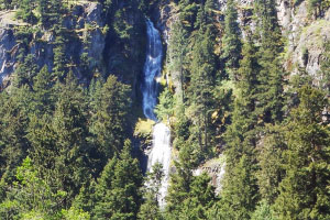
Snoquera Falls
Height: 400 ft.
Form: tiered plunges
Accessibility: moderate hike
At 400 feet, this is one of the tallest falls on the north side of Mt. Rainier National Park. Located on the east side of the White River canyon, Snoquera Falls can be viewed from the highway for a look at the entire falls or via the Buck Creek or Snoquera Falls Trail, where the excitement happens, at its base. Visit during May-June (and sometimes as early as April) for high flows. After winter melt off, the falls’ flow decreases dramatically in the summer and fall.
Read More
Close